Early 2000s | Original proof of concept c. 2002-2003

IRIS: Building an Early Connected Public-Safety Platform

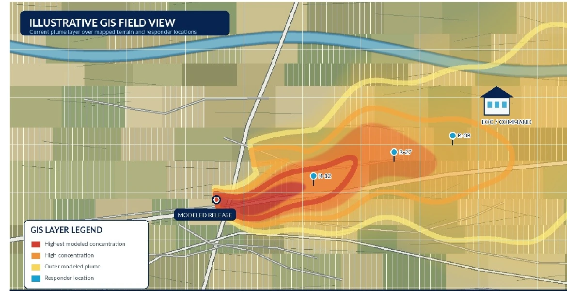
Real-time chemical-plume GIS, mobile field computing, wireless infrastructure and incident operations. Before smartphones, app stores, cloud GIS and modern mobile broadband, IRIS moved the current chemical-plume GIS layer itself into responders' hands, field laptops and emergency operations centers.

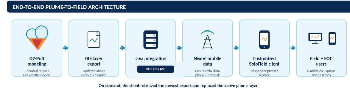
Vlad's role: overall solution architect and primary developer/integrator for the original IRIS proof of concept and plume-to-field capability. He defined the end-to-end architecture, directed required adaptations by the D2-Puff and SoloField product teams, developed the Java integration server and connecting components, and proved the concept over Nextel before the regional Wi-Fi environment existed.
Illustrative GIS field view showing the current chemical-plume layer and responder locations
Representative reconstruction - not an original incident display.
c. 2002-03Original proof of concept
450+400 laptops plus 50+ rugged handhelds
2 yearsPrimary operational support owner
Through 2010Multi-year expansion and operations
IRIS was a suiteNot a single application
Plume-to-field GISOPS ConsoleRegional Wi-FiMicrowave + fiber backhaulCameras + videoField + EOC systems
Independent evidenceIRIS and the regional deployment were covered contemporaneously by government sources, national trade publications and technology media.See the original coverage ↓
Original IRIS proof of concept

How IRIS moved live GIS data from the lab to the field.

The proof of concept existed before the regional Wi-Fi network. It used commercial Nextel mobile data, a standalone Java server and a customized mobile GIS workflow to prove that current plume information could reach responders wherever they were operating.

End-to-end IRIS plume-to-field architecture
D2-Puff exported an updated GIS layer approximately every ten minutes. On demand, the responder pressed Update in the customized SoloField client, which retrieved the newest layer through Nextel and replaced the active plume display.

What Vlad owned

  • Overall architecture: defined the complete data flow from modeling output to responder use.
  • Requirements and direction: specified the product changes needed from D2-Puff and SoloField.
  • Development: wrote the Java server and connecting client/server integration components.
  • Field proof: demonstrated the concept over Nextel before the regional Wi-Fi system existed.
  • Multi-platform delivery: replicated the capability on rugged handhelds, field laptops and Windows desktops at area emergency centers.

Collaborative product contributions

  • D2-Puff developers added the GIS-layer export capability under Vlad's requirements and technical direction.
  • SoloField developers adapted the mobile GIS client and update behavior under his requirements and technical direction.
  • Emergency-management and responder stakeholders supplied operational needs, exercise participation and user feedback.
  • The larger implementation team later contributed network sites, installation, administration and infrastructure expansion.
Why this was so early

In 2002-2003, field communications still centered on radio, phone calls and basic text. IRIS moved the current, location-aware GIS layer itself to responders.

c. 2002Operational need2002-03POC over Nextel2003-04Federal expansion2004-05Handheld + Wi-Fi rolloutLaterExercises + support
Engineering constraints Vlad had to solve
Slow mobile dataDesigned the update cycle around early Nextel bandwidth and coverage limitations.
Limited rugged hardwareWorked within severe memory, processing, display and storage constraints.
Early mobile GISAdapted a specialized GIS client before modern mobile mapping platforms existed.
Multi-vendor integrationMade modeling, GIS, server, carrier and field-device components operate as one workflow.
Installer, technician and field foundation

IRIS was not solely a software-development assignment.

During deployment and operation, Vlad also worked hands-on across sites, connectivity, wireless infrastructure, field devices, testing, installation support, troubleshooting and agency-user needs.

This demonstrates the installer/technician/field-tech foundation beneath his later engineering, project-management, presales and technical-leadership roles. He did not merely design software and hand it off; he supported the infrastructure and users required to make the complete environment function.

Installation + deployment supportSupported sites, connectivity, field devices, rollout activities and formal exercises.
Hands-on troubleshootingPersonally diagnosed failures across network, server, application, device and field boundaries.
Wireless + infrastructure supportWorked across regional links, public-safety sites, emergency centers, servers and connected devices.
Agency + responder supportSupported operational users, field equipment, incident workflows and continuity after deployment.
Team delivery context: the broader infrastructure build was collaborative. Other contributors performed portions of physical site construction, network installation, backend administration, system administration and other technical and operational work. Vlad's role crossed major project responsibility, systems integration, technical coordination, field support and direct troubleshooting; it does not imply that he personally built every site or installed every network component.
OPS Console - a separate creation within IRIS

A distinct software product that became part of the IRIS suite.

IRIS was a suite of software and hardware technologies. OPS Console was a distinct web-based product within that suite, separate from the regional communications and video infrastructure.

Conceived, designed, developed and completed by Vlad

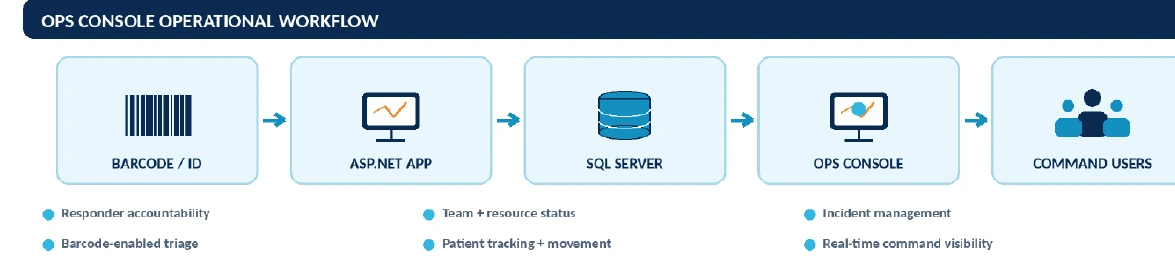
Vlad conceived the product and operational workflow, designed the application and data model, led development and personally completed OPS Console as an ASP.NET application with a Microsoft SQL Server backend. Another developer worked under his direction for part of the effort.

  • Product ownership: defined responder, team, incident, triage and patient-tracking workflows.
  • Technical ownership: designed the application and database-backed operating model.
  • Development leadership: directed another developer, then resumed direct development and finished the system personally.
ASP.NETWeb application
SQL ServerDatabase backend
Built by VladConcept, design, development
Part of IRISSeparate product within the suite
OPS Console operational workflow
OPS Console extended IRIS beyond plume awareness into responder accountability, team and resource status, incident coordination, barcode-enabled triage, patient movement and real-time command visibility.
Responder accountabilityAutomatic or barcode-assisted registration and arrival status.
Team + resource statusAvailable personnel, teams and operational resources.
Incident managementShared incident status and command visibility.
Barcode-enabled triageCoded patient identification and field workflow support.
Patient trackingPatient movement and destination visibility.
Command visibilityCurrent operational information for EOCs and medical personnel.
Operational readiness

OPS Console was used in formal exercises, tested extensively and ready for activation during a real chemical incident. Fortunately, that incident never occurred.

Training + adoption

Vlad created the IRIS training program and personally trained all participating first responders on use of the complete IRIS suite - not only plume viewing or handheld operation, but the full field, desktop and operational workflow.

Regional Wi-Fi, microwave/fiber backhaul and digital video

Building the regional communications and video environment.

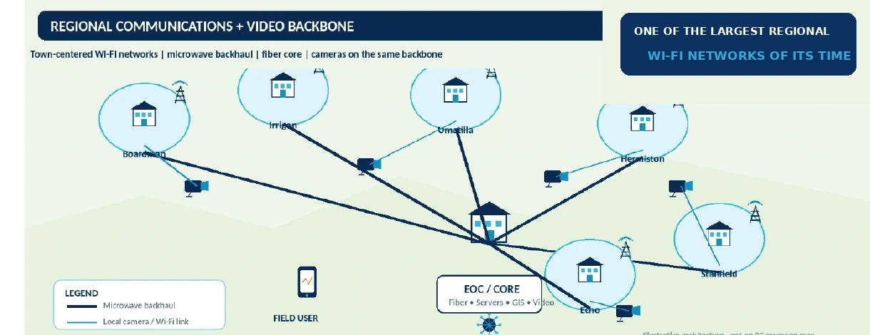
Federal expansion turned the proven concept into a rural, multi-community public-safety environment. Town-centered Wi-Fi networks were backhauled by microwave into fiber, and the digital cameras used the same regional backbone.

450+400 laptops + 50+ rugged handhelds
30Networked cameras reported
3Command centers reported
Illustrative regional communications and video backbone
Town-centered Wi-Fi, microwave backhaul, fiber core, cameras and emergency centers. One of the largest regional Wi-Fi networks of its time. Illustrative architecture - not an RF coverage map.

Technical project leadership

Held major project responsibility across the multi-year expansion, agencies, vendors and contributors.

Systems integration

Connected wireless links, microwave/fiber backhaul, servers, GIS, cameras, applications, devices and emergency centers.

Technical coordination

Translated operational needs into assignments and decisions across product and infrastructure teams.

Hands-on troubleshooting

Personally diagnosed failures across network, server, application, device and field boundaries.

Field + deployment support

Supported sites, connectivity, field devices and agency users through rollout and exercises.

Camera + video responsibility

Operated the digital-camera server and prepared targeted incident video for law-enforcement users.

Digital video operations from camera sites through regional Wi-Fi, microwave and fiber to police video
Vlad operated the central camera server, located requested footage and prepared custom incident video for law-enforcement users.
Team delivery context: other contributors performed physical site construction, network installation, backend administration, system administration and other technical and operational work. Vlad's role crossed project leadership, systems integration, technical coordination, field support and direct troubleshooting.
Operational ownership

From deployment and adoption to end-to-end operational ownership.

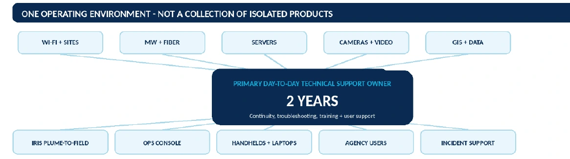
After the major buildout, Vlad became the primary - effectively sole - day-to-day technical support resource for the mature integrated environment for approximately two years.

Operational ownership across Wi-Fi, microwave and fiber, servers, cameras, GIS, IRIS, devices and users
Continuity, troubleshooting, training and user support crossed the complete technology stack rather than one application or one vendor product.
The complete story

Vlad architected and proved the original IRIS plume-to-field solution, created OPS Console, built the IRIS training program and trained all participating first responders, helped technically deliver the funded Wi-Fi, microwave/fiber and digital-video expansion, and then kept the mature multi-agency environment operating.

Architecture + softwareDefined the original IRIS operating model; built the Java server and ASP.NET / SQL Server OPS Console.
Training + adoptionCreated the complete IRIS training program and personally trained all participating first responders.
Program delivery + integrationCoordinated agencies, vendors and contributors while connecting modeling, GIS, networks, video, devices and users.
Troubleshooting + ownershipDiagnosed cross-boundary failures and supported continuity across the mature environment for two years.

Why it mattered: before smartphones, 4G/5G and cloud GIS, IRIS moved the current GIS layer from a specialized model into responders' hands.
What this demonstrates today

The product details are historical. The operating capability is current.

IRIS is not presented as a product VERO currently sells. It demonstrates the ability to turn an unproven operational concept into a functioning multi-vendor platform and remain accountable from architecture through adoption, field operation and long-term support.

Complex solution architectureDefine the complete operating model and technical interfaces.
Multi-vendor integrationDirect specialized contributors and connect their work into one solution.
Technical program ownershipCoordinate agencies, vendors, developers, engineers and field resources.
Wireless and field infrastructureConnect design, installation, deployment, troubleshooting and user needs.
Training and operational adoptionTranslate a technical system into field, desktop and command workflows users can operate.
Operational troubleshootingDiagnose cross-system failures and preserve continuity after delivery.
The project details change. The operating method does not.

Understand the real problem, connect the disciplines, make the solution executable and own the outcome.

Independent contemporary coverage

Original reporting documents IRIS and the regional deployment.

These are not generic references or retrospective marketing claims. Government sources, national trade publications and technology media covered the platform, handheld plume maps, regional wireless network, cameras, operations console and historical context at the time.

Independent evidence, publicly accessible today
01Security Magazine2004

Emergency Responders Rely on Handhelds

IRIS handhelds, live plume maps, barcode wristbands and field reporting.

Open original coverage ↗
02U.S. DOJ / OJP / NCJRS2005

Hermiston Puts Mobile Computing to the Test

50+ Recon handhelds, plume overlays, field communications and regional Wi-Fi.

Open original coverage ↗
03Nextgov / FCW2005

One Big Wireless Net

Proxim, Nextel, SoloField GIS, digital video and federal expansion.

Open original coverage ↗
04Government Technology2010

Oregon Protects Communities From Deadly Chemical Weapons

D2-Puff, cameras, command centers, operations console and awards.

Open original coverage ↗
05Wi-Fi PlanetDeployment era

Wireless Watches the Gas

Rural multi-town network, early launch and Proxim infrastructure.

Open original coverage ↗
06Microsoft / TDS2003

Windows Mobile 2003 Launch Partner

Historical context for the newly released rugged mobile platform.

Open original coverage ↗
Apply the capability

Need an architect-builder who can also work through field realities and delivery?

I can bring the same operating range to complex solution architecture, integration, specifications, RFPs, project delivery, technical recovery, and operational problem solving.